
Pakistan is a relatively small country in South Asia. Pakistan is blessed with beautiful landscapes and locations. One of the unique features of the beauty of Pakistan is that it is blessed with all sorts of environments. If you go to the north of Pakistan you will find tall mountains that are covered with snow year around huge glaciers that melt and bless the rivers with their waters. In the south you will find the desert plains of Sindh where it doesn’t rain for decades. In the central Punjab region you will find lush green planes full of fields and farmers. In the West you will find the rough plateaus of Balochistan and the indigenous traveling herdsmen. Pakistan is not only blessed with great diversity in land but also in weather. Pakistan has all four seasons. During the rainy season the monsoon winds cause heavy rainfall that quenches the thirst of our fields. In winter the temperature at k2 peak reaches below -60 degree Celsius. In summer the temperature reaches nearly 50 degree Celsius in cities like Dadu and Jacobabad. Pakistan is also located on many fault lines so earthquakes are also common in Pakistan. One of the strongest earthquakes occurred in 2013 in Awaran, Kech region. It had a magnitude of 7.7 on the Richter scale. In fact Pakistan is famous all Around the world for its hospitality. All of these qualities combined with its heterogeneity in culture, terrain, environment and weather make it a great travel destination for tourists from all around the world. It is because of this fact that in 2018 Pakistan was crowned the no 1 travel destination by british backpackers society. Some of the most amazing places and their details are given below.
Gilgit is a beautiful city and capital city of Gilgit-Baltistan region in the north Pakistan. Thousands of tourists visit Gilgit from all around the world every year. gilgit was once the center of the Buddhist world. Gilgit was also an important stop point for people traveling on the Silk Road. Gilgit is now a tourist hub for tourists from all around the world who visit the Northern areas of Pakistan. Some tourists come here only to visit the gilgit city and travel around the city at night and collect local souvenirs from the Bazaar here. While some come here to start their hiking and trekking expeditions or supply before moving on. A lot of national and international mountaineers from all around the world come here to start their expedition to climb the world’s second tallest peak K2. Gilgit itself is also very beautiful located at the sangam of the appropriately named Gilgit River and famed Hunza River named after the beautiful Hunza Valley. Whatever the reason you visit Gilgit you will not be disappointed by its beauty and hospital.
There are many ways you can get to Gilgit. You can directly fly there which is more convenient but flights are limited to only a few times a week due to adverse weather conditions. You can also go there on many of the local buses but the journey is long, rough and tiring.
Once you are there in Gilgit city you can find many local places to spend the night. Even though the wider Gilgit-Baltistan is rough with adverse weather there aren’t many places there where you can stay. but in Gilgit city itself you won’t have any problems finding a place to stay as it is a very important trade hub for tourists visiting the Gilgit-Baltistan region.
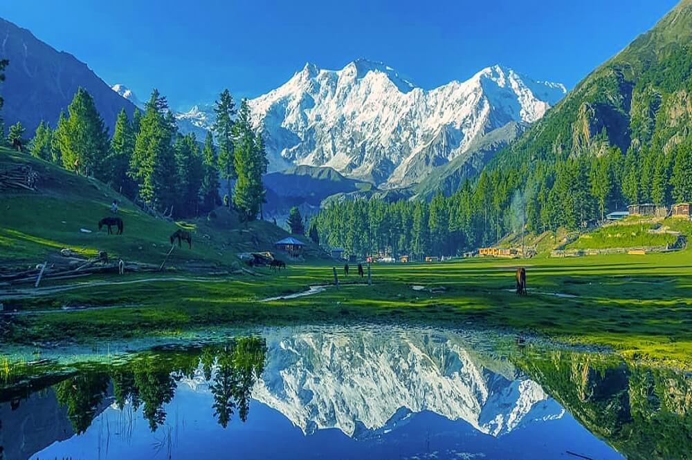
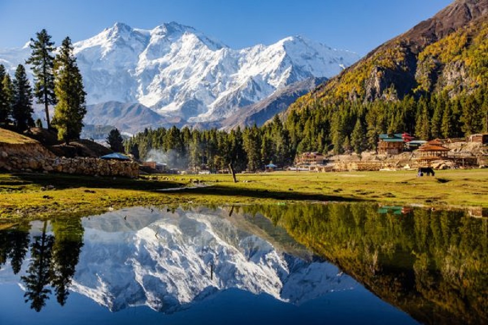
Locally known as Joot but more popularly known as Fairy Meadows is a grassland. The fairy Meadows was named by German climbers because of its immense beauty. The lush green meadows and heavenly views of this place reminded them of the fantasy tales of fairies and their land. The fairy Meadows is located at the base of “The Killer Mountain” (Nanga Parbat) in the Diamer district of Pakistan. Don’t get scared because of the name killer mountain because it is named as such because of the fact that many mountaineers have died while climbing this mountain but the Fairy Meadows itself is completely safe as it is located at the base of the mountain away from all the danger. However, keep in mind that the road leading up to the Fairy Meadows was ranked as the world’s second scariest Road mainly because of its high elevation and landsliding.
However the Fairy Meadows makes up for all of this with its vibrant grasslands, terrific views and tranquil environment. if you decide to go to Fairy Meadows then first you need to take a bus ride from Gilgit city to Ranikot bridge and from there you will pick a ride on Jeep to the rough trail ahead finally from there you can either hike up there on foot or hire a horse if you aren’t that good at climbing. When you reach fairy Meadows it is recommended that you spend the night there and do some star gazing at night time.
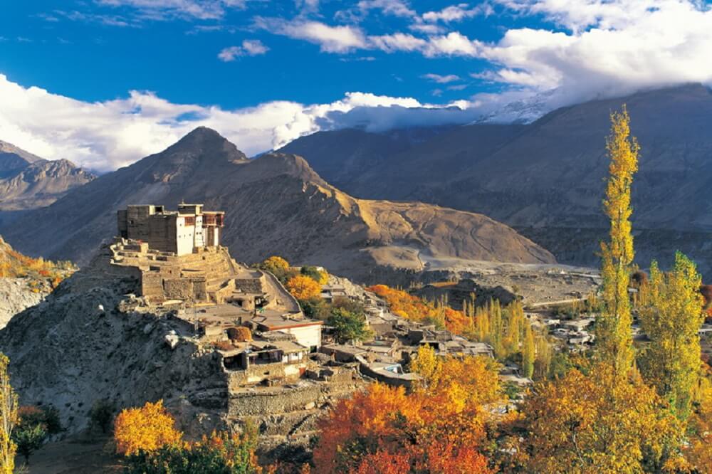
Hunza Valley is a small valley in the Gilgit-Baltistan. Hunza Valley is formed by the gaping Hunza River that flows beside the valley. The valley itself is located at an incredible elevation of 2400 m. The valley is famous for its rich cultural history. The valley was originally of Buddhist majority and some of the Buddhist religious temples and sites still survive to this day. Later when Islam arrived in this region through the islamic merchants majority of the population converted to Islam and the remaining monks either died in hiding or fled to other regions. Some aspects of its Buddhist culture survive to this day. The capital of Hunza Valley is the city of Baltit also referred to as Karimabad. The city is very beautiful with Buddhist and Islamic inspired architecture and buildings.the terrain of this place makes it perfect for backpacking, hiking, camping and tracking. Baltit is only 2.5 hours from another beautiful city of region Gilgit. Even though unfortunately a lot of historic architecture was destroyed due to lack of care, their restoration was taken up by the Historic Cities Program and was completely executed. The few historic sites that still exist to this day include The Altit Fort and The Baltit Fort. These were once the domicile of the ruler also referred to as Mir of the valley. Keeping aside the historic significance of this valley the beauty is also praise worthy.from a nearby popular tourist spot called The Eagles Nest you can get a birdseye of this majestic and empyreal Valley.
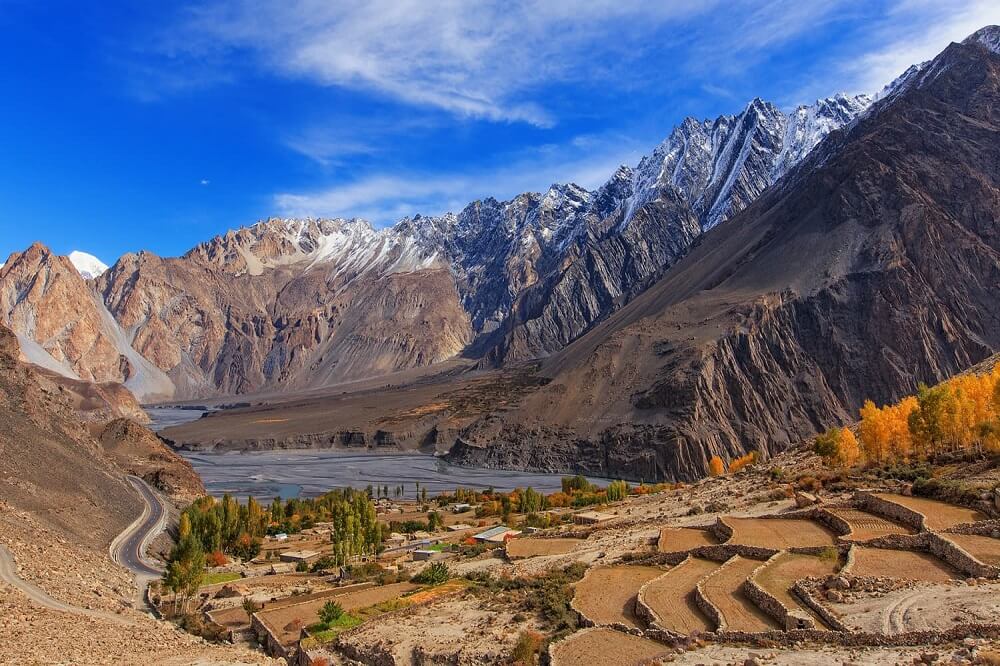
Gojal, also called upper Hunza, is a part of the Hunza Valley. Gojal along with Hunza actually consists of many smaller and few larger villages. It is located near the Khunjerab Pass on the Karakoram Highway and neighbors China. Gojal also has amazing views of one of the longest glaciers on the earth, the Baltoro Glacier. Gojal borders Afghanistan at the magnificent Chipurson valley whose population mainly consists of Wakhi people scattered in multiple villages throughout the valley. Gojal also has a beautiful and newly formed Attabad lake as a result of a landslide. Gojal has many beautiful views of various different terrains including snow capped peaks, glaciers and lush green meadows. You can also bring your own tent and camp at any place you want. Gojal is a beautiful valley with various cultures and traditions and where people of various ethnic backgrounds coexist.
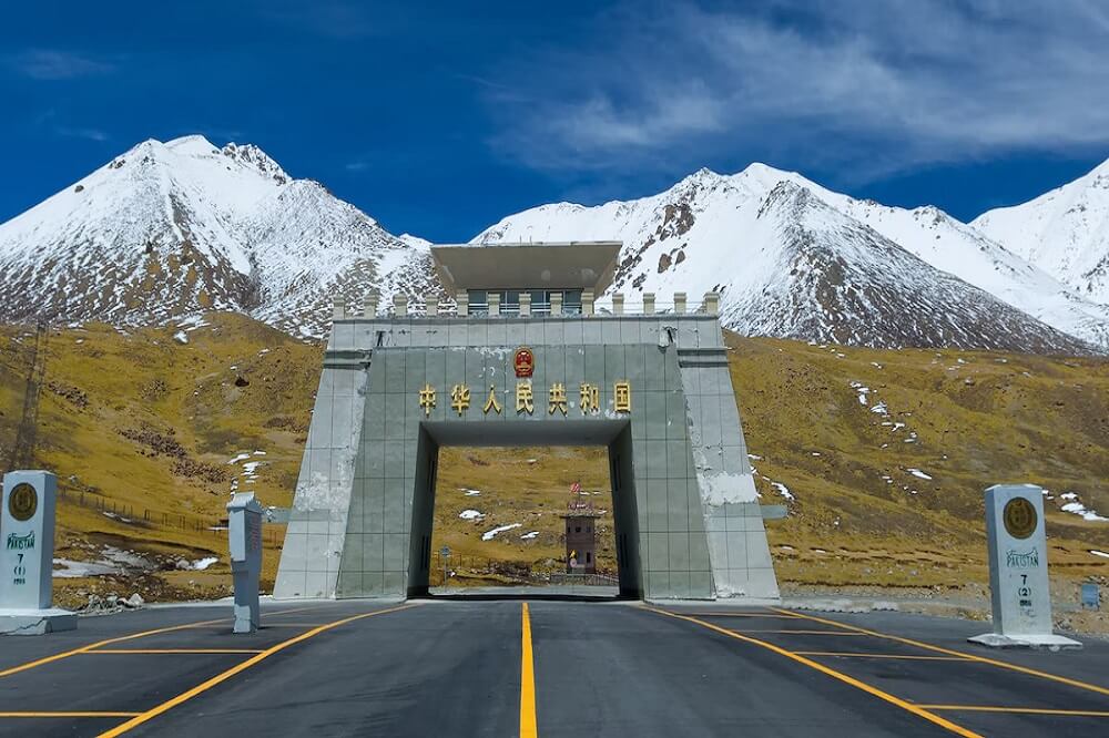
Khunjerab Pass is a mountain pass located at the Pak-China border in the Karakoram mountains. It is at an elevation of about 4700 m. It is a beautiful marvel of modern engineering with beautiful views of the snowy Karakoram mountains. Unfortunately there isn’t any form of public transport that goes to the Khunjerab Pass but you can take your own car or rent / hire a private vehicle to take you there. On the way to Khunjerab Pass you will also get a chance to see the famous Hussaini Bridge, considered the world’s most dangerous bridge and the splendid Passu Suspension Bridge with an amazing view of the Passu Glacier.
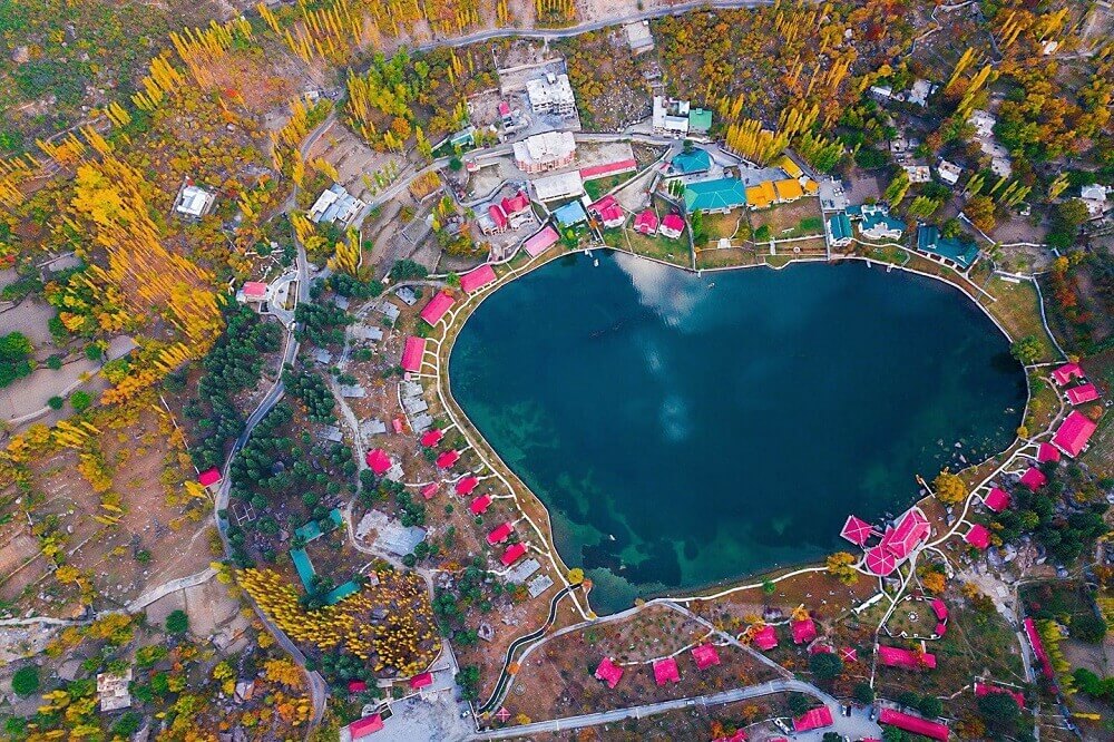
Skardu is a beautiful city also in the Gilgit-Baltistan region. It is only 5 hours away from Gilgit city. The name Skardu means the place between two high places as it is located in the Skardu Valley between the Satpara lake and Shigar city. The city itself is at an elevation of 2500 m. It is at the sangam of Shigar River and Indus river. There are many popular tourist spots near Skardu like Skardu Cold Desert, Khaplu palace once the residence of the raja or ruler of this place and Manthal Buddha Rock. There are many places to spend the night in Skardu as it is a very popular tourist destination. One of the famous hotels here is the famed Shangrila Resort famous for their luxurious rooms and menus. One of the most famous places here is the ruminative Shangrila Lake named after the famous “Shangri-La” city , a mysterious place mentioned in the famous novel “Lost Horizon” authored by James Hilton which was published in 1933. It is a beautiful lake with an amazing view where the water and the sky seem to merge.
We are a company that will take you on incredible trips. We’ll lead you down the road to a place that is awe-inspiring with eye-catching views and astounding destinations.